Google: using AI satellites to tackle wildfires
Juliet Rothenberg knows firsthand the fear and uncertainty people experience when facing devastating wildfires. When, four years ago, her California neighbourhood was evacuated she and her family spent the next few hours looking at satellite imagery for reassurance and answers. But none came.
Juliet, who is the Product Director of Climate AI work at Google Research, faced the same challenge as countless researchers, scientists and firefighters: poor data and a critical gap in existing wildfire detection.
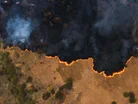
Current satellite imagery used for firefighting is only available at low resolution or is updated only a few times each day. This makes it difficult to detect serious fires until they have grown as large as a football field.
“We had no idea if our neighbourhood was safe,” says Juliet. “All we received was updated satellite imagery every 12 hours, while throughout the Bay Area, the sky was red and full of smoke.”
Google Research using AI to prevent devastation
In early March 2025, Juliet stood with her Google Research colleagues at Vandenberg Space Force Base to watch the launch into orbit of a solution designed to tackle this challenge: FireSat.
The result of a partnership with the Earth Fire Alliance, the Gordon & Betty Moore Foundation and Muon Space, FireSat is a purpose-built satellite constellation that uses AI and high-resolution multispectral satellite imagery to provide near real-time insights on wildfires.
The first FireSat was carried into space aboard SpaceX’s Transporter-13 mission. It will form part of a constellation of more than 50 that will use AI to detect and track wildfires only 5x5 metres in size.
It will provide updated high-resolution images every 20 minutes, designed to give first responders greater speed and certainty when tackling wildfires. AI compares the latest image with thousands of previous shots, considers local weather and atmospheric conditions, then determines if fire is present.
“Some satellites today take a picture about every five minutes, but they’re coarse,” notes Chris Van Arsdale, Google Research and Chairman, Earth Fire Alliance. “You’re lucky if you can see the city of San Francisco in the image. You’re certainly not going to see where a fire is until it’s a few acres in size.” Compounding this, many wildfires begin in mountainous areas where planes and drones may not fly to gather images.
Deploying responsible AI
In late 2024 Google.org provided US$13m funding to kickstart the Firesat initiative, which is led by nonprofit organisation the Earth Fire Alliance.
The Google Research team, part of Google’s AI division, developed custom infrared sensors designed to detect small-scale fires more effectively. During the development process these were flown over controlled burn areas to establish a baseline dataset for the satellite’s AI model.
The satellite’s AI model is capable of deep analysis of imagery, including considering nearby infrastructure and weather. “Differentiating between real fires and random ‘noise’ in the environment was a challenge,” adds Chris. “We had to determine where to draw the line between what is a real fire versus things like sensor issues or misaligned pixels.”
Such was the effectiveness of this process that, in one of the first tests, the sensors picked up a lit barbecue in someone’s garden.
As well as tackling existing fires, FireSat will be used by scientists to create a global historical record of fire spread to help understand wildfire behaviour.
“FireSat is more than just an emergency response tool,” Juliet explains. “It’s also an incredible tool for reducing greenhouse gas emissions. It’s actually really beautiful that the constellation contributes to reducing climate change — while also responding to it.”

To read the full article in the magazine, click HERE.
Explore the latest edition of AI Magazine and be part of the conversation at our global conference series, Tech & AI LIVE.
Discover all our upcoming events and secure your tickets today.
AI Magazine is a BizClik brand